Potential Sudden Stratospheric Warming (SSW) Alert 🚨
Models hint at a significant Polar Vortex weakening with signs of Sudden Stratospheric Warming, potentially impacting winter weather in the Northern Hemisphere.
Understanding the Polar Vortex and its Link to Surface Weather
The "Polar Vortex" is a meteorological term describing a large, persistent, and rotating low-pressure system centered near the Earth's poles, primarily in the stratosphere. It's a consequence of the temperature gradient between the cold polar regions and the warmer mid-latitudes. During the polar winter, prolonged darkness leads to intense radiative cooling, causing the air to become extremely cold in the upper atmosphere.
This cold air mass is surrounded by a strong polar jet stream —a narrow, fast-flowing ribbon of air in the stratosphere. The jet stream acts as a boundary, confining the polar air within the polar vortex. The result is a closed, cyclonic circulation pattern.
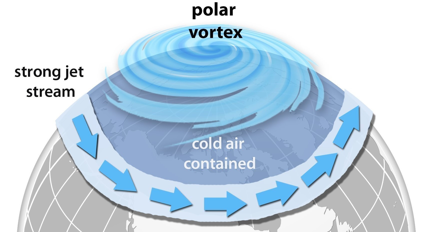
In meteorology, the Polar Vortex is a high-altitude (10 hPa), cold-core cyclonic circulation centered around the poles, maintained by the temperature contrast between polar and mid-latitude regions and constrained by the polar jet stream.
The Connection with the Tropospheric Jet Stream
The Polar Vortex's interaction with the Polar Jet Stream, a high-altitude, fast-flowing air current in the troposphere, is crucial. The Jet Stream's undulating waves influence surface weather patterns, triggering the development of weather systems like cyclones or storms.
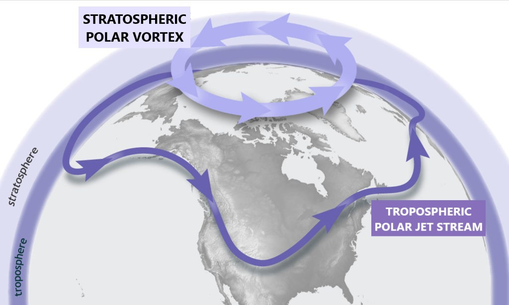
The Jet Stream, a high-altitude, fast-flowing air current in the troposphere, plays a crucial role in shaping weather patterns, particularly in the Northern Hemisphere. Its path meanders from west to east and is positioned at the boundary between cold air to the north and warmer air to the south.
The Jet Stream's undulating waves influence the formation of weather systems on the surface. When these waves become amplified, they can trigger the development of low-pressure systems, known as cyclones or storms. These systems, in turn, drive the movement of air masses, influencing weather conditions across vast regions.
Now, let's connect this to the Polar Vortex in the stratosphere.
The Polar Vortex up there acts like a guardian, corralling cold air around the poles. When the Polar Vortex weakens or becomes disrupted, it can have a domino effect on the Jet Stream in the troposphere. This disruption can lead to the meandering or "wavy" pattern of the Jet Stream, influencing the weather systems it guides.

When the Polar Vortex weakens or is disrupted, it can influence the Jet Stream's pattern, leading to a meandering or "wavy" flow that impacts the steering of weather systems at the surface.
Sudden Stratospheric Warming 📈🌡️ Unraveling the Disruption of the Polar Vortex.
A sudden stratospheric warming (SSW) is a meteorological phenomenon characterized by a rapid increase in temperatures in the stratosphere, particularly over the polar regions. When an SSW occurs, it can disrupt the usual structure of the Polar Vortex in the stratosphere. Instead of a strong, circular flow, the vortex may weaken, split, or be displaced from its typical polar location.
This disruption can extend downward, influencing the behavior of the Jet Stream in the troposphere. An SSW event, by altering the Polar Vortex, can induce a waviness or meandering in the Jet Stream. This, in turn, affects the steering of weather systems and air masses at the surface.
SSW acts as a top-down mechanism, where stratospheric changes impact the troposphere. The interconnected relationship between the Polar Vortex, Jet Stream, and SSW events highlights atmospheric processes shaping weather patterns.
Signs are pointing to a Sudden Stratospheric Warming event around January 4-5, promising potential shifts in the Polar Vortex and Jet Stream dynamics. Get ready for a meteorological rollercoaster! ❄️
Current indicators suggest the imminent occurrence of Sudden Stratospheric Warming (SSW) around January 4-5, potentially disrupting the Polar Vortex and influencing the Jet Stream. Meteorological models increasingly support this prediction.
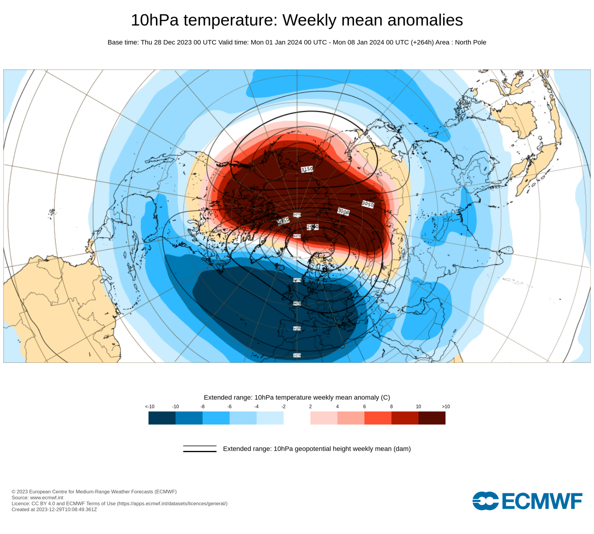
⚠️ However, the relationship between SSW and surface weather, particularly in regions like Spain, is intricate, with tropospheric dynamics playing a significant role. Daily monitoring is crucial for confirmation. If the trend persists, January may experience a notable shift. The broader impact of SSW on Earth's surface weather is substantial, though the precise connection remains a topic of ongoing research.

Precipitation and temperature at 2 meters weekly mean anomalies from 1 to 8 of January (left) and from 8 to 15 of January (right). Source: European Centre for Medium-Range Weather Forecasts
Winter change on the horizon – a glimpse into the impending Sudden Stratospheric Warming event
In the coming days, a potential Sudden Stratospheric Warming (SSW) event is anticipated, suggesting a significant weakening of the Polar Vortex and potential impacts on winter weather in the Northern Hemisphere. Understanding the Polar Vortex's connection with the tropospheric Jet Stream is crucial, as disruptions in the former can lead to meandering flows in the latter, influencing surface weather patterns. Current indicators point to a potential SSW event around January 4-5, promising shifts in the Polar Vortex and Jet Stream dynamics. While meteorological models support this prediction, ongoing monitoring is necessary to decipher the intricate relationship between SSW and surface weather, especially in regions like Spain, with potential consequences for weather conditions in January 🌦️